


 wallpaper Inspired by a post at Geology Rocks; base photo from here. Ah, rocks. How I love pounding on you.
Showing posts with label Geology. Show all posts
Showing posts with label Geology. Show all posts
wallpaper Stand Back!
wallpaper Inspired by a post at Geology Rocks; base photo from here. Ah, rocks. How I love pounding on you.
wallpaper How Much is a Planet Worth?
Gliese 581 c: $160
Mars: $14,000
Earth: $Lotsa!
From BoingBoing:
The interview portion of the article goes into some detail of how the equation was pieced together, and helps clarify how this works. Still wondering about magnets and tides, though.
Mars: $14,000
Earth: $Lotsa!
From BoingBoing:
Our planet's value emerged as nearly 5 quadrillion dollars. That's about 100 times Earth's yearly GDP, and perhaps, Laughlin thought, not a bad ballpark estimate for the total economic value of our world and the technological civilization it supports.I find this kind of amazing, that one can simply plug in numbers regarding physical characteristics of a planet- quantities that don't, on the face of it, seem to have much to do with economic value- and get something that seems like a plausible estimation of the "worth" of the planet. $14,000 seems like a low value for Mars, to me, but I suspect that's at least in part because I think about its potential future value, not its value in terms of today's ability to utilize it.
The interview portion of the article goes into some detail of how the equation was pieced together, and helps clarify how this works. Still wondering about magnets and tides, though.
wallpaper Not Telling.
I need to just stop reading press releases. Seriously. They either piss me off or disappoint me. This one does both:
Thanks, perfesser.
New model for how Nevada gold deposits formed may help in gold explorationSo silly ol' me, I kind of assumed this might tell me something about a new model for Nevada (Carlin-type) gold deposits, and how this might help in exploration for such deposits. HA! Here's the closest it gets:
The team relates formation of the gold deposits to a change in plate tectonics and a major magma event about 40 million years ago. It is the most complete explanation for Carlin-type gold deposits to date.So after reading what is, to be fair, not a bad summary of what Carlin-type deposits are- though redundant for me- the press release ends with that. Five minutes wasted. Sigh. This is my theory, which is mine, and it is, as follows, mine: Brontosauruses were narrow at the end, much, much thicker in the middle, and then thinner again at the other end.
Thanks, perfesser.
wallpaper Extreme Hikes at Extreme Heights
I've posted an older video of El Camino (Caminito) Del Rey before, but this one, from last year, is almost twice as long, and every bit as gut wrenching:
By the way, I just realized that the "old" (i.e. "functional") embed code is still available at YouTube; I'll be going back and fixing Saturd80's in a bit.
The hiking trails at China's Mount HuaShan are in far better repair, but I have enough acrophobia that I still wouldn't be able to cope.
In both cases, I'd dearly love to visit these spots: the landscapes and rocks are beautiful. But I get queasy just looking at the clips. I know for a fact I'd be utterly paralyzed if I went there in person. On a positive note, according to the Wikipedia page (link above) for El Caminito Del Rey,
The regional government of Andalusia budgeted in 2006 for a restoration plan estimated at € 7 million.So apparently, in the not-too-distant future it will be possible for humans who aren't part mountain goat, part spider to enjoy this trail once again. I, on the other hand, will most likely stick to gentler landscapes.
The President of Malaga Provincial Government, Salvador Pendon, announced that the budget to restore the three-kilometre walkway is €8.3m, financed by the provincial government.
The project will take approximately three years from when it is due to start in mid-2011.
wallpaper Cycles Without End
Note: January 31- This wedge has been accreted at Mountain Beltway. Lots and lots of geo-themed goodies to check out and drool over. Take a look!
The theme for this month's Accretionary Wedge (#30), hosted by Callan Bentley, is "Bake Sale."
So instead of another geocake- believe me, there are some really nice ones lined up- I've decided to focus more literally on "the interconnections between geology and food." When you're finished with this post, you will have not only (I hope) a better understanding of how baked goods are created, but a fun activity to do with students that helps drive home the deep connection between the non-living earth and its inhabitants. It probably won't be obvious where I'm going at first, but bear with me. wallpaper (Elemental calcium from Wikipedia) Above is a test tube of calcium (Ca). For each of the elements I mention here, I will introduce it by name, follow it by its symbol, then stick mostly with the symbol or a compound name afterward. If the sample above was not enclosed in a test tube, it would react quickly with the atmosphere to form an earthy coating of oxides and nitrides. I don't know if calcium is available to the general public in the US, but it is readily available to classroom teachers and not too expensive.
After a few minutes, the Ca will fully react and quit bubbling off H2, and what remains will be a cloudy suspension of Ca[OH]2 precipitate and solution. Place a filter paper in a funnel, and filter the mixture into an Erlenmeyer flask to remove the lime precipitate. The resulting supernatant should be more or less clear, but a small amount of cloudiness is unimportant. (Alternatively, simply letting the mixture settle for a while will allow you to pour or siphon off a clear portion of the solution, but this may not be practical in the time-limited classroom setting. Also, the teacher can simply prepare sufficient solution for classroom use ahead of time.)
If you followed the link to lime water above, you now know that this solution can be used as a test for carbon (C) dioxide, CO2. In fact, if you let it sit undisturbed and exposed to air, it will develop a thin crystalline crust as it reacts with CO2 in the atmosphere. But we're going to use a more concentrated source of that gas- ourselves.
Using a straw, exhale through the solution. Using Erlenmeyer flasks, with their constricted tops, helps to minimize splashing. Placing a piece of paper over the mouth of the flask can also help catch splashes, and as I mentioned earlier, S's should wear goggles. The solution will quickly turn cloudy, but continue blowing through it for several minutes. Keep in mind, the point is simply to expose the solution to CO2, not to make it as explosively splashy as possible (which some students will endeavor to do). The latter can also lead to hyperventilation and is a bad idea.
 wallpaper When exposed to CO2, clear limewater turns milky- image from chem.wis.edu.
The precipitate that results from blowing through the lime water is CaCO3, or calcite. While technically not a mineral (see my discussion of what does and doesn't constitute a mineral here) because we created it, and thus it's technically not "natural," for most purposes we can consider this to be the same as micrite, or limy mud, which most often forms in calcium carbonate-saturated, warm, marine environments. Now, to me at least, there is something very amazing- I'm hesitant to use the word "magical," which connotes a very pleasurable state of mind to me, but holds a different meaning to most people, and one I don't intend- about this "artificial micrite." Those tiny mineral grains were, only a few moments earlier, alive! And not just alive, but me! What just came out of my lungs is instantly, "magically," a sediment on a tropical sea floor! I hope this excitement is not uniquely mine, because this intimate relationship between myself and natural earth processes is at the heart of my love of geology. It's certainly not the only thing there, but it is one of the central attachments.
Next step: either filter off the CaCO3, or allow it to settle (which may take 5-10 minutes, I don't remember exactly, but it's not too long) and pour off the supernatant. The goal here is to isolate and concentrate the precipitate, and how that's done is not important. Once you have the isolated precipitate, add a drop or few of acid: 0.1 M HCl, if you have it, but vinegar will work fine too. The acid test for calcite, if positive, will yield fizzing CO2, as the CaCO3 reacts to give a Ca salt, water, and CO2 gas. Again, the CO2 gas from acidifying your "micrite" is pretty special: a very short time ago it was tied up in cells all over your body. You are seeing a component of cellular waste that you rarely think about, and almost never directly perceive (unlike urine, for example). wallpaper Calcite reacts with acid to form CO2, from About.com Geology
So, I hear you pleading, what in gawd's name does this have to do with baking? Well, it's that carbonate component, which within the limits imposed by typing, I'll designate --CO3: a carbonate ion with a minus 2 charge. There are unleavened breads- flour-based foods that have no component that causes them to rise- but these tend to be leathery or, if thick, downright brick-like. They are generally considered to be less desirable than leavened breads (though I have to admit, I'm a fan of crackers and lebkuchen). Yeast breads get their rise from cellular wastes of the yeast cells- again, carbon dioxide gas. But the majority of flour-based food we think of as cake and pastry have as their leavening agent sodium (Na) bicarbonate, NaHCO3. Cookie recipes often call for baking soda- which is sodium bicarbonate. The heat causes basically the same decomposition as the acid does for our calcite, but more slowly and more gently, giving leavened cookies a little loft and making them softer.
More bready, cakey pastries often call for baking powder, which are mixtures of sodium bicarbonate and temperature/moisture activated acids. From the wikilink:
How many times, on average, has each carbon atom in the earth's near-surface cycled from the non-living lithosphere, atmosphere or hydrosphere into a living organism and back out to the non-living earth? I don't doubt that people far more competent than I have struggled to find meaningful and accurate estimates for this question. But I'm content to settle for the somewhat flippant answer "lotsa." And carbon is just one element- albeit the most important- among quite a number that are also biologically important. Every other element mentioned in this post, Ca, H, O, Na, and even Cl (chlorine) would be considered biologically important: life as we know it couldn't function without them. Along with carbon, each of those elements goes through its own cycles, its own set of reservoirs, of uses and transformations from non-living to living and back again.
And every time you take a bite of cake, and sigh blissfully, the cycle repeats once again.
The theme for this month's Accretionary Wedge (#30), hosted by Callan Bentley, is "Bake Sale."
I hereby challenge my fellow geobloggers (and any newbies who want to participate) to explore the interconnections between geology and food. This can take any form you want, but I’m really hoping for some edible, geologically accurate models.I'm actually fairly proficient in the kitchen, and I particularly love the alchemy that is baking: there is something magical (more about my use of that particular word later) about starting with an inedible white powder, and ending up with bread, pastries, cake or cookies. But lack of funds and difficulty getting to the grocery store makes it effectively impossible for me to actually create something of my own. (On the other hand, I have posted a number of these sorts of things other people have created in the past; my favorite is here.)
So instead of another geocake- believe me, there are some really nice ones lined up- I've decided to focus more literally on "the interconnections between geology and food." When you're finished with this post, you will have not only (I hope) a better understanding of how baked goods are created, but a fun activity to do with students that helps drive home the deep connection between the non-living earth and its inhabitants. It probably won't be obvious where I'm going at first, but bear with me.
 wallpaper (Elemental calcium from Wikipedia) Above is a test tube of calcium (Ca). For each of the elements I mention here, I will introduce it by name, follow it by its symbol, then stick mostly with the symbol or a compound name afterward. If the sample above was not enclosed in a test tube, it would react quickly with the atmosphere to form an earthy coating of oxides and nitrides. I don't know if calcium is available to the general public in the US, but it is readily available to classroom teachers and not too expensive.
SAFETY: CaO and the Ca[OH]2 solution are moderately caustic. Goggles should be worn, and for younger S's, you might want to consider latex/neoprene/plastic gloves. Students (S's) should be instructed to quickly wash off any skin contacts with either material, and to clean up any spills. These materials are pretty mild, as caustics go, but prolonged contact can cause chemical burns, and eye contact should be taken quite seriously- rinse for several minutes, and at a minimum, call for medical advice, though an ER visit would most likely not be necessary. H2 generated is flammable, and in large amounts, explosive, but in a decently ventilated space, and lacking ignition sources, this shouldn't be an issue.So to start, place a small amount of Ca- a few grams- into a beaker or flask, then add water, let's say 50-75 ml. Calcium reacts quickly (though gently) with water to create hydrogen (H- in the real world, this exists as the diatomic molecule H2) and calcium hydroxide (also called "slaked lime," Ca[OH]2, where O is oxygen). The hydrogen can be harvested and used for other purposes, but that is beyond my scope here. The real goal here is to get that Ca[OH]2 solution, and a cheaper way, realistically, is simply to dissolve lime (CaO) in water. As it happens though, it's always been more convenient to use Ca, which has been available in every classroom I've worked, than lime, which is very inexpensive, but generally comes in unusable amounts (100 pound bags), and has never been laying around for me to use. A solution of calcium hydroxide is called, colloquially and archaically, "lime water."
After a few minutes, the Ca will fully react and quit bubbling off H2, and what remains will be a cloudy suspension of Ca[OH]2 precipitate and solution. Place a filter paper in a funnel, and filter the mixture into an Erlenmeyer flask to remove the lime precipitate. The resulting supernatant should be more or less clear, but a small amount of cloudiness is unimportant. (Alternatively, simply letting the mixture settle for a while will allow you to pour or siphon off a clear portion of the solution, but this may not be practical in the time-limited classroom setting. Also, the teacher can simply prepare sufficient solution for classroom use ahead of time.)
If you followed the link to lime water above, you now know that this solution can be used as a test for carbon (C) dioxide, CO2. In fact, if you let it sit undisturbed and exposed to air, it will develop a thin crystalline crust as it reacts with CO2 in the atmosphere. But we're going to use a more concentrated source of that gas- ourselves.
Using a straw, exhale through the solution. Using Erlenmeyer flasks, with their constricted tops, helps to minimize splashing. Placing a piece of paper over the mouth of the flask can also help catch splashes, and as I mentioned earlier, S's should wear goggles. The solution will quickly turn cloudy, but continue blowing through it for several minutes. Keep in mind, the point is simply to expose the solution to CO2, not to make it as explosively splashy as possible (which some students will endeavor to do). The latter can also lead to hyperventilation and is a bad idea.
wallpaper When exposed to CO2, clear limewater turns milky- image from chem.wis.edu.The precipitate that results from blowing through the lime water is CaCO3, or calcite. While technically not a mineral (see my discussion of what does and doesn't constitute a mineral here) because we created it, and thus it's technically not "natural," for most purposes we can consider this to be the same as micrite, or limy mud, which most often forms in calcium carbonate-saturated, warm, marine environments. Now, to me at least, there is something very amazing- I'm hesitant to use the word "magical," which connotes a very pleasurable state of mind to me, but holds a different meaning to most people, and one I don't intend- about this "artificial micrite." Those tiny mineral grains were, only a few moments earlier, alive! And not just alive, but me! What just came out of my lungs is instantly, "magically," a sediment on a tropical sea floor! I hope this excitement is not uniquely mine, because this intimate relationship between myself and natural earth processes is at the heart of my love of geology. It's certainly not the only thing there, but it is one of the central attachments.
Next step: either filter off the CaCO3, or allow it to settle (which may take 5-10 minutes, I don't remember exactly, but it's not too long) and pour off the supernatant. The goal here is to isolate and concentrate the precipitate, and how that's done is not important. Once you have the isolated precipitate, add a drop or few of acid: 0.1 M HCl, if you have it, but vinegar will work fine too. The acid test for calcite, if positive, will yield fizzing CO2, as the CaCO3 reacts to give a Ca salt, water, and CO2 gas. Again, the CO2 gas from acidifying your "micrite" is pretty special: a very short time ago it was tied up in cells all over your body. You are seeing a component of cellular waste that you rarely think about, and almost never directly perceive (unlike urine, for example).
 wallpaper Calcite reacts with acid to form CO2, from About.com Geology
So, I hear you pleading, what in gawd's name does this have to do with baking? Well, it's that carbonate component, which within the limits imposed by typing, I'll designate --CO3: a carbonate ion with a minus 2 charge. There are unleavened breads- flour-based foods that have no component that causes them to rise- but these tend to be leathery or, if thick, downright brick-like. They are generally considered to be less desirable than leavened breads (though I have to admit, I'm a fan of crackers and lebkuchen). Yeast breads get their rise from cellular wastes of the yeast cells- again, carbon dioxide gas. But the majority of flour-based food we think of as cake and pastry have as their leavening agent sodium (Na) bicarbonate, NaHCO3. Cookie recipes often call for baking soda- which is sodium bicarbonate. The heat causes basically the same decomposition as the acid does for our calcite, but more slowly and more gently, giving leavened cookies a little loft and making them softer.
More bready, cakey pastries often call for baking powder, which are mixtures of sodium bicarbonate and temperature/moisture activated acids. From the wikilink:
Common low-temperature acid salts include cream of tartar and monocalcium phosphate (also called calcium acid phosphate). High-temperature acid salts include sodium aluminum sulfate, sodium aluminum phosphate, and sodium acid pyrophosphateWhy didn't I base this activity around sodium carbonate/bicarbonate rather than calcium carbonate? It would involve NaOH, which is seriously caustic, and something I prefer not to mess with if there are sensible alternatives. Further, as I tried to express above, there is something awesome and mesmerizing to me about seeing a mineral that was only moments ago part of my own metabolism. This is a critical understanding of the sciences generally, and geology specifically: life is of the earth. We have no constituent components that were not originally unliving. The food we eat, the air we breathe, and the water we drink, we think of these as separate from ourselves, but fundamentally ours. From the perspective of the planet, though (and granting that in any real sense, "the perspective of the planet" is a nonsensical phrase), those components are not separate, and they fundamentally belong to the earth more than they belong to us. We are granted the privilege of using them for a short time.
How many times, on average, has each carbon atom in the earth's near-surface cycled from the non-living lithosphere, atmosphere or hydrosphere into a living organism and back out to the non-living earth? I don't doubt that people far more competent than I have struggled to find meaningful and accurate estimates for this question. But I'm content to settle for the somewhat flippant answer "lotsa." And carbon is just one element- albeit the most important- among quite a number that are also biologically important. Every other element mentioned in this post, Ca, H, O, Na, and even Cl (chlorine) would be considered biologically important: life as we know it couldn't function without them. Along with carbon, each of those elements goes through its own cycles, its own set of reservoirs, of uses and transformations from non-living to living and back again.
And every time you take a bite of cake, and sigh blissfully, the cycle repeats once again.
wallpaper I Slept Through the Big One
311 years ago today, a so-called "great earthquake" struck the coastal region of the United States Pacific Northwest. Here's my post from last year explaining some of the details of why we think we know this; I'm not going to rewrite it here. However, this year's anniversary is somewhat special for another reason: Oregon conducted its first "shakeout" to encourage preparedness for the inevitable next great quake at 10:15 this morning.
I slept through it.
Unfortunately, metaphorically speaking, so did public awareness. @GlacialTill pointed out earlier that many members of his geology department weren't even aware of it. I was aware of it, and its coincidence with the anniversary, but it was sort of a peripheral awareness, something to which I wasn't paying attention. As I mentioned to him, this is our first such event, so expectations shouldn't be too high. On the other hand, I see my own complacent attitude toward the exercise as cautionary and a little shaming: if a person who is pretty well informed and concerned about this issue is essentially ignoring the shakeout, how can he expect that the general public will catch on? As it turns out, slightly more than 1% of Oregonians are reporting their participation.
So in the spirit of trying to do better next time, here are some links, resources and commentary. The official homepage is here, and the graphic at the bottom claims "Over 37,000 participants." Of particular interest to me are the instructions for how to react at the onset and for the duration of a quake (and the page upon which these instructions are apparently based, with more detail and explanation).
Unfortunately, I think the biggest failure during this first attempt was the lack of media coverage. As I commented to GlacialTill, I remember quite a few cursory articles last fall when the drill was announced. I thought about writing up a post then, but decided to wait until it was closer with the assumption I would be reminded by news releases. I know I've seen at least one article on the event during the last week, but I can't find it now. An article from KVAL (which I do skim over) shows up in Google- though not my RSS- but the link goes to a generic search page with no results. There have been a few articles and press releases, but not in places where I might have seen them without an intentional search. For example, despite my general contempt for press releases, this one at Newswire is very well done, in my opinion. (Oregon State University source is apparently here, with some links I haven't followed yet.) This one, from Portland's Fox affiliate, is shallow and cursory, but at least it's something. A brief at Medford's News Tribune notes the event... in this morning's edition. This seems like a day late to me, at least, but again, it's something.
I don't want to point fingers here- I think it would be wrong-headed and counterproductive. Further, as I implied above, I do not hold myself unaccountable. Between one route and another, I estimate I get somewhat fewer than a thousand readers a day. This is certainly a situation where a trivial amount of effort on my own part could have- likely would have- made a significant and substantive difference. The Medford article claims that 24,000 participants were anticpated, so the actual number tallied thus far- which may increase- is better than 50% higher than expected.
Still.
I don't think Oregonians, Washingtonians and British Columbians have fully grasped the disruption we're talking about here. Roads, water, power, airports, hospitals, food distribution and all sorts of other physical and social infrastructure that we take for granted are likely to be knocked out for weeks, or, at the very best, functioning at very low levels of efficiency. Are you ready for that? Have you really thought about what that means?
It could strike in the next few minutes. It might not strike within the lifetimes of children born today. We don't know. To say it becomes more likely as time goes on, I think, would be misleading: seismologists and structural geologists are constantly reassessing their understandings of how stress and strain are relieved and distributed at any given moment and through time. For example, the recently discovered "slow quakes" of the PNW (that article is also a pretty good back-grounder) are still mostly mysterious. Do they concentrate strain and make a great quake more likely, or relieve strain and make one less likely? We don't know.
Given the unknowns, the potential consequences, and relatively low hassle and cost of being prepared, it seems obvious to me that being prepared is clearly preferable. As I said in last year's post, there is some good news here. I don't feel bleak about the situation. But I do feel we could be doing better.
As I looked back over the above to proofread for obvious errors, one sentence jumped out at me: "This is certainly a situation where a trivial amount of effort on my own part could have- likely would have- made a significant and substantive difference." I earnestly hope and pray you don't recall that sentence as you huddle in the rubble with your family, wondering when help will arrive.
Followup: Glacial Till, a geology student in Portland, and About.com Geology (Andrew Alden) have posted on The Shakeout as well. Both mention, as I forgot to, that British Columbia also conducted a shakeout. Glacial Till notes that the reported participation in BC is 460,000. Wikipedia says the population of that province is about 4.5 million, so that's a 10% participation rate, even though this is their first such event as well. C'mon, Oregon. We can do better. And Washington? You might want to come along next year.
Followup 2: I was half expecting this would get some after-the-fact coverage, despite there being effectively no coverage ahead of time. The Portland Tribune chimes in with the first such article I've seen, and I'll post any similar reports here as I come across them.
wallpaper Lotsa Water
I think Anne at Highly Allochthonous was the first to post this, along with some great discussion and explanatory hydrographs, but because RSS gives you the most recent articles first, I first saw it at KATU and OregonLive. The OL article has a more standard news perspective, if you're not into Anne's hydrogeological approach. KATU also has a story surveying tentative plans to restoring the wiped-out road, which no longer exists: the Sandy River is currently flowing where the road used to be. (Followup, 6:28- OregonLive also has a piece about reconstruction of the road, and an excellent aerial photo of the damage.)
Anne also mentions the February '96 floods, which I recall vividly. I was not out and about during those, though I did go downtown one afternoon to look at the water encroaching toward 2nd street, and it was not until mid-May when I found a field trip completely disrupted by washed out, debris-covered or severely damaged roads that I understood at a gut level how bad that set of floods had been. There are several areas in the Quartzville Creek drainage that I've been keeping a curious eye on for the last fifteen years, watching the recovery as plants have recolonized and various processes conspire to slowly hide the geological evidence of that mess.
As Anne correctly points out, last weekend's flood was not such a big deal- yes, it caused some local problems, and a number of people have lost possessions and homes, but no one was killed, and as far as I've seen no one was even hurt, though there may have been some discomfort when the power failed. As scary as the above footage is, in my mind, this was a good disaster: no casualties and awesome documentation. Another example of a good disaster was last year's volcanic eruption in Iceland. (No, I'm not going to look up, copy and paste its spelling.)
Other, much more seriously attention-deserving floods have occurred already in this young year, namely in Brazil and Australia. Today's Big Picture (The editor is moving on to another position, but says Boston.com's photo staff will continue the blog) showcases the Brazilian flooding and associated landslides/debris flows. And January 3rd, the same feature shared photos of the Australian floods. These two and other flood events (for example, "Sri Lanka, which suffered a 1-in-100 year flood this month.") are discussed in meteorological detail by Dr. Jeff Masters at his Wunderblog, who says
So yes, it has been a wet and mucky winter here in western Oregon, as was predicted when a La Nina developed in the second half of 2010. But overall, it could be a lot worse.
Followup: Heehee... just found this. Is it related enough? Sure, why not.
 wallpaper
see more Lolcats and funny pictures
Anne also mentions the February '96 floods, which I recall vividly. I was not out and about during those, though I did go downtown one afternoon to look at the water encroaching toward 2nd street, and it was not until mid-May when I found a field trip completely disrupted by washed out, debris-covered or severely damaged roads that I understood at a gut level how bad that set of floods had been. There are several areas in the Quartzville Creek drainage that I've been keeping a curious eye on for the last fifteen years, watching the recovery as plants have recolonized and various processes conspire to slowly hide the geological evidence of that mess.
As Anne correctly points out, last weekend's flood was not such a big deal- yes, it caused some local problems, and a number of people have lost possessions and homes, but no one was killed, and as far as I've seen no one was even hurt, though there may have been some discomfort when the power failed. As scary as the above footage is, in my mind, this was a good disaster: no casualties and awesome documentation. Another example of a good disaster was last year's volcanic eruption in Iceland. (No, I'm not going to look up, copy and paste its spelling.)
Other, much more seriously attention-deserving floods have occurred already in this young year, namely in Brazil and Australia. Today's Big Picture (The editor is moving on to another position, but says Boston.com's photo staff will continue the blog) showcases the Brazilian flooding and associated landslides/debris flows. And January 3rd, the same feature shared photos of the Australian floods. These two and other flood events (for example, "Sri Lanka, which suffered a 1-in-100 year flood this month.") are discussed in meteorological detail by Dr. Jeff Masters at his Wunderblog, who says
NOAA's Climate Prediction Center currently puts the La Niña event in the "strong" category, and whenever a La Niña or El Niño event reaches the strong category, major perturbations to global weather patterns occur. This typically results in record or near-record flooding in one or more regions of the globe.Still, keep in mind some aren't sharing in this hydrologic wealth. An article that I would have read but probably not mentioned here, if not for the fortuitous context in which to place it, notes Prineville's water woes. Prineville is in the center part of Oregon, on the other side of the Cascades, and thus in their rain shadow. Trying to infer between the lines of this article, it sounds as if the problem is more about the groundwater geology and conserving scarce surface water resources rather than simply the dry climate, but the community is bumping up hard against the water limit, whatever the cause. "The reason the city is so interested in developing better wells is because, as it stands now, the city does not have the capacity to serve its existing residents, Klann said."
So yes, it has been a wet and mucky winter here in western Oregon, as was predicted when a La Nina developed in the second half of 2010. But overall, it could be a lot worse.
Followup: Heehee... just found this. Is it related enough? Sure, why not.
wallpaper wallpaper Oh My.
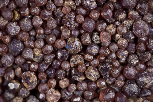
Via Swans on Tea, I found this Flickr collection of sand photos (two pages) by "Mouser NerdBot". Oh my. I need to catch my breath. Now here's the thing I really appreciate: the photographer has done an excellent job of labeling the location and composition of the samples, even, for example, explaining how the garnets below were concentrated from an "ant sand." Check out the enormous original size photos too!  wallpaper
 wallpaper
 These garnets were extracted from ant sand. Garnet is paramagnetic and can be separated from its surroundings in sand with a strong magnet. These garnets range in size from 1mm to 5mm in diameter. There are presumably larger garnets in the soil in this area, but with ant sand you are limited to things ants can lift and carry.
wallpaper Another Riveting Paleontology Documentary
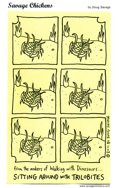 wallpaper (Savage Chickens) Dinosaurs are cool, don't get me wrong. And I almost never watch television, so honestly, I don't know if this has even been done (Though I do know BBC did First Life, I don't know if it has aired in the US... well, okay, according to Wikipedia, it has.) But the fact that some extinct animal, or plant, for that matter, isn't a dinosaur, isn't gigantic, and isn't (gasp!) even a vertebrate doesn't mean it's dull. So while I enjoy the above comic, I sort of resent the attitude that spawned it. (This shouldn't be taken as a criticism of Doug Savage, the artist, but rather of broad attitudes in our society.)
wallpaper Sand Through the Hourglass: Bits of Geoscience
I'm feeling pretty uninspired. Between staying up too late reading (for several nights running) and what might be a mild cold- which may or may not be part and parcel with the weird, mild headaches that make me feel as if my skull is deforming like a kneaded lump of clay- I just want to go home and go to bed. But I have a backlog of interesting geology and earth science posts I've been meaning to get to, plus a couple more that came up today, so with a minimum of fuss here are some recent bits from the geoblogosphere and related news.
- Silver Fox spent much of the weekend tracking down the original Dutton quote poetically describing Basin and Range as an army of caterpillars crawling north out of Mexico. Like Ron Schott, I'm most familiar with this from the sign at Dante's View in Death Valley, but this has clearly been misquoted many more times than quoted.
- Callan has a slew of mashed-up rocks (what I personally think of as metacrappite, in my own mental categorization of rock groups, without the slightest bit of derogatory intent), in his continuing series on the geology of San Francisco. Also check out the mashed cherts; these are some of the hardest and most competent sedimentary rocks that exist, and to see them folded, spindled and mutilated like taffy should give you a profound respect for the power of the earth.
- Christmas day's EPOD was a stereopair of a beautiful snowflake. I've been meaning to transform this into a wobble-gif, but haven't got to it. I may not. Like I said at the outset...
- Cian at Point Source summarizes her highlights from the recent AGU conference. I'm intrigued by the emphasis I've seen, and not only in her post, on scientists taking a lead role in communicating on their disciplines. As I and numerous others have repeatedly noted, the journalists just aren't getting it done.
- Evelyn at Georneys has a wonderful post about a wonderful map. As familiar as this beautiful bit of cartographic art is to me, I had never realized its importance, nor how recently (alright, okay, I get it, I'm old.) it had been completed. Heartfelt thanks for clarifying, Evelyn.
- Bryan at Hot Topic summarizes a recent interview of James Hansen by Bill McKibben, highlighting the degree of confidence felt among climate scientists regarding global warming, its consequences, and how to ameliorate its effects.
- NatGeo has a gallery of images of what are thought to be collapse pits over lava tubes... on Mars.
- The Guardian has the most complete article I've seen on the reopening of Molycorp's Mountain Pass rare earths mine.
- In a semi-related bit of economic news, Krugman's column today deals with rising commodity prices in a recovering economy, on a finite planet. As I've noted before, geology and economics are much more intimately related than I think most people recognize.
- Also at The Guardian, an article that largely dismisses concerns over the recent news about Cr VI in US drinking water. He makes some valid points, and in my reading, I had already come to much the same conclusion- that the panicky reaction was overblown. However, I think the middle ground is more appropriate here. There's no reason to panic, but his level of dismissiveness is unwarranted as well. This should be of concern, and should be studied more carefully.
- Louisiana will be coming to Oregon to study hurricane storm surges. Huh? Oregon State University has one of the largest wave tanks in the world: The Hinsdale Wave Research Laboratory.
- The explosion and subsequent destruction of the Deepwater Horizon, and the ensuing oil spill, made the new chairman of The House Science and Technology Committee, Ralph Hall (R-Texas), feel all warm and fuzzy inside.
"As we saw that thing bubbling out, blossoming out – all that energy, every minute of every hour of every day of every week – that was tremendous to me," he said. "That we could deliver that kind of energy out there – even on an explosion."
You probably don't want to read that entire article if you would prefer to be optimistic regarding science in the US in the near future.
wallpaper The Age of The Earth
When I talk about my age, or my birthday, or similar topics, I have a base line of a documented day I was born and started breathing the atmosphere. When we talk about the age of a tree, we may be talking about a known planting date or the number of annual growth rings counted near the base. For a manufactured item, it might be known from its container, or make and model from a car, and can often be inferred at least approximately from stylistic changes through the years. In each case, there is a particular point in time that we consider a starting point: birth, first growth, manufacturing.
With something like an entire planet, it gets a little more complicated.
There's a new geotweep, Geologic Time, who is planning to tweet our planet's history as it would occur over the course of time if its ~4.54 billion years were compressed into one calendar year. I signed up to follow the other day because it sounds like a fun exercise and because while, yes, I know a great deal about earth history, I expect there will be any number of facts and tidbits that are new to me.
So when Geologic Time tweeted earlier (in a piece that has now apparently been taken down) that the proto-earth was currently in the process of accretion- planetesimals and rocky material falling together to form the young planet- I tweeted back asking "So what defines when protoplanet becomes 'Earth?'" In other words (I meant) what was the moment, event, or datum of some kind, that geoscientists use to say, "Before this point, it was proto-earth; after this point it was earth." Because there has to be a starting point, right?
Well, the short answer appears to be, "No, not exactly." The accretion process was messy and hot. The proportion of radionuclides- which decay and release more heat- was much higher than today. So there are no datable rocks from our planet's earliest history, and thus nothing on our planet that can be dated. The oldest known rocks are about 4 billion years old, and the oldest known mineral grains are detrital zircons from the Jack Hills of Australia, at about 4.4 billion years. The latter value represents an absolute minimum age for the earth.
My assumption had been that there had been more work done with the lunar samples. I know a lot of work and analysis has been done with those over the last 25 years, and I haven't followed it very carefully. I was also quite aware that the precision of radiometric dating had improved a great deal during that interval. As it turns out though, the planetary midnight of 1/1 is still the same as it was when I was a student: the age of the material that created the earth. Meteorites. I've been reading a bit on this topic since it came up this morning, and I'm not going to go into great detail, but essentially, we have the lower bound of about 4.4 billion years and an upper bound of meteorite ages of about 4.55 billion years. The earth had to have formed between those two times.
Wikipedia did offer one bit of information that was new to me, though. "Nevertheless, ancient Archaean lead ores of galena have been used to date the formation of Earth as these represent the earliest formed lead-only minerals on the planet and record the earliest homogeneous lead-lead isotope systems on the planet. These have returned age dates of 4.54 billion years with a precision of as little as 1% margin for error." So there are two independent and consistent paths that get us to the currently accepted age: meteorites and Archaean galena. One particularly interesting inference that I'm tentatively drawing from all this is that the time from protoplanetary disk to fully accreted planets must have been quite short in the grand scheme of things- maybe ten million to a hundred million years, tops.
The two links included above are both to Wikipedia, but two other sites I found particularly informative were Talk Origins, which appears to be primarily to provide ammunition for those refuting young-earthers, and Palaeos.com, The Hadean Age. The latter provides a description and discussion of what happened when during the first eon of the planet's history, and why we think so. From a distance of billions of years, it makes for fascinating and exciting reading, but I'm glad I wasn't there for it. Both have references from as recently as 2007, so while they may not be utterly current, they have definitely helped me come more up to date than I was a few hours ago.
wallpaper I'm Gonna Be SOOOOO Bad!
 wallpaper This is indeed Bad Science... solar panels don't use "fuel" so to discuss their "fuel efficiency" is nonsensical. Make mine anthracite or jet.
 wallpaper Anthracite
 wallpaper Jet
wallpaper Where to Go In Case of Eruptions
 wallpaper Okay, some of what I learned regarding volcanism as an undergrad still holds true. I guess advances in magma genesis by forces of mythological folklore have rendered the whole partial melting and fractional crystallization idea obsolete, but the surface processes of flows and ignimbrites seem to be pretty much unchanged. From I Need It Quickly.
wallpaper Reviewing The Year's Geology News
The Onion reports on the unpronounceable Icelandic volcano and its eruption earlier this year:
The eruption was initially attributed to Huldufólk elves believed to be angry at mortals for the desecration of their rock dwellings during the winter of 2009. While gifts of sweets to the elves seemed to produce small gaps in the ash that allowed airspace to be briefly reopened, the cloud as a whole lingered. It was only after millions of travelers had already spent days stranded at airports that embarrassed officials finally conceded that another creature was probably responsible.It's official: my understanding of geology and volcanism is out of date.
After ruling out the 300-foot Lagarfljóts worm, investigators concluded that only Grýla—best known for emerging from her cave at Christmastime in search of naughty children to stuff in a sack—possessed the power necessary to generate an eruption of Eyjafjallajökull's magnitude. By then, however, many food items shipped by air had begun to spoil, and a number of world leaders had already missed the funeral of Polish president Lech Kaczyński.
Subscribe to:
Posts (Atom)


